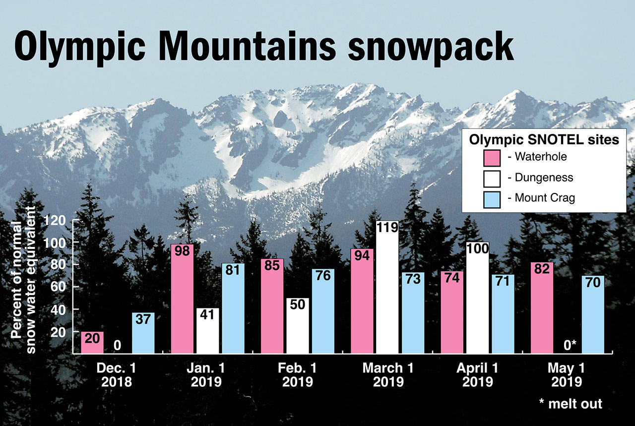
PORT ANGELES — Olympic Mountain snowpack has slipped well below normal and will melt rapidly as temperatures climb this week, a water supply specialist said.
Snowpack was 72 percent of normal Tuesday as measured at two snow telemetry sites operated by the U.S. Department of Agriculture’s Natural Resources Conservation Service.
Normal is defined as the median snowpack from 1981 to 2010.
A more comprehensive monthly snowpack measurement revealed a 61 percent snowpack in the Olympics on May 1, said Scott Pattee, a water supply specialist with the Natural Resources Conservation Service in Mount Vernon.
“I feel there is some concern, and I think others do, too,” Pattee said of the water supply outlook.
Snowpack, a measurement of the water content in the snow, provides a reservoir of meltwater for municipal water supplies, irrigation and fish habitat in the dry summer and early fall.
Pattee said the latest water supply forecast calls for a dry summer, perhaps similar to 2009, but not as parched as 2015.
“We’ll do one-more [water supply] forecast on June 1,” Pattee said.
“If May stays hot and dry, these forecasts are going to drop drastically by June 1.”
The National Weather Service was calling for a warm spell through this weekend and the likelihood of a relatively warm and dry May.
Temperatures were forecast to climb into the mid-80s this week in Forks and Brinnon and the mid-70s in Port Angeles, Sequim and Port Townsend.
“The next several days are warm and dry,” said Gary Schneider, a meteorologist with the National Weather Service in Seattle.
“It’s going to start to cool off this weekend and early next week, but we are looking at several days of above normal temperature until then, and so that will melt the snow faster than normal.”
Schneider added that the three-month outlook calls for the probability of above normal temperatures and slightly below normal precipitation in May, June and July.
Daily snowpack averages are taken at three USDA snow telemetry (SNOTEL) sites in the Olympic Mountains: Waterhole, Dungeness and Mount Crag.
The 4,870-foot Buckinghorse site in the upper Elwha basin measures snowpack but is too new to be used in the 30-year average.
The 4,010-foot Dungeness site melted out recently and is no longer being used in the daily average, Pattee said.
Olympic National Park also conducts field snowpack measurements called snow courses, or on-site mapping, at Hurricane Ridge, Cox Valley and Deer Park, Pattee said.
The monthly on-site mapping is combined with the telemetry data to yield Olympic Mountain snowpack measurements Jan. 1, Feb. 1, March 1, April 1 and May 1, Pattee said.
Olympic National Park officials reported that snowpack had dropped to 53 percent of normal May 1.
“The dry March and a warmer than normal April have contributed to this change from mid-winter,” Olympic National Park officials said on the park’s Twitter feed Thursday.
“Snow is already patchy in many areas and we are likely to see areas melt out two weeks earlier than normal.”
Snowpack was close to normal in the Olympic Mountains in the mid-winter, when parts of the North Olympic Peninsula lowlands were socked with more than a foot of snow.
Pattee said the park arrived at the 53 percent figure by dividing the averages of the snow telemetry and on-site mapping areas by six.
“That sometimes works, and sometimes that doesn’t work,” Pattee said.
“The official May 1 number is 61 percent.”
“They were just using different math.”
Last year on May 1, Olympic Mountain snowpack was 136 percent of normal using the array of snow telemetry sites and on-the-ground measurements.
Pattee said the snow telemetry sites appeared to have healthier snow packs than the snow courses because of where they are positioned.
A dismal snowpack in the winter of 2014-15 led to water shortages and fishing restrictions in parts of the North Olympic Peninsula the following summer.
________
Reporter Rob Ollikainen can be reached at 360-452-2345, ext. 56450, or at rollikainen@peninsuladailynews.com.

