EDITOR’S NOTE: This story has been corrected from its original transmission to note that the fire is on Makah reservation land, not DNR property.
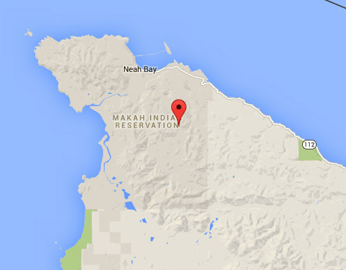
NEAH BAY — An estimated 40-acre blaze has put Neah Bay on the list of communities in the state with a neighboring wildfire this drought season.
The fire has burned slash and 1-year-old trees along 200 Line Road southeast of Neah Bay, state Department of Natural Resources officials said Monday.
The fire is on Makah reservation land about a mile from the nearest neighborhood, and though it is active, it is not expected to spread, officials said.
“Right now, we’re not too concerned about it threatening any [buildings],” said Tim Perciful, public information officer for the incident management team.
“It’s up in an area that’s been logged. . . . It’s in a lot of slash.”
The cause of the fire has not been determined. It was believed to have begun at about 11 a.m. Saturday, Perciful said.
Perciful credited Makah firefighters for making an effective initial attack.
“They had everything really well organized,” he added.
DNR crews were joined Monday by tribal firefighters, a Clallam County Corrections Center crew and Olympic National Park and Olympic National Forest officials.
Clallam County Fire District No. 3 sent one engine to the fire Sunday, Clallam County Fire District No. 2 Chief Sam Phillips said.
Perciful estimated that there were 70 firefighters and 100 personnel at the scene Monday.
Crews were improving fire lines and trucking in water to battle the blaze, he said.
Perciful said he did not have an estimate on the fire’s containment.
Firefighters caught a break from the weather Monday as cool, marine air pushed through the area.
Today’s forecast for Neah Bay calls for areas of drizzle and fog becoming partly sunny with a high of 61, the National Weather Service said.
Mary Verner, deputy supervisor for DNR, said in a Friday news conference that there had been 747 wildfires since June 1, most of which were lit by people.
Those fires have burned a combined 74,000 acres of land, about double the acreage of a normal fire year, Verner said.
Paradise Fire
Meanwhile, the Paradise Fire in Olympic National Park grew by 169 acres Sunday, according to measurements made during a flight by fire managers late Sunday night.
Fire managers used an infrared system to locate areas of heat in the fire area, and a new fire map was created using that data, said Mark DeGregario, spokesman for the managers of the fire burning on the north side of the Queets River valley, 28 miles southeast of Forks.
The fire’s spread reached 1,781 acres, according to the mapping system.
On Sunday morning, the fire had burned 1,612 acres and had been burning at a rate of about 10 acres a day.
The weekend’s high temperatures and low humidity over the fire encouraged Sunday’s fire growth, DeGregario said.
The National Weather Service forecasted cooler weather with high humidity and the possibility of light showers for the next few days, which is expected to slow the fire’s progress.
The rain will not be enough to extinguish the fire, and the fire is expected to flare up again when conditions heat up and dry out, said incident commander Jason Loomis.
The Paradise Fire is burning in heavy, old-growth rainforest on steep valley walls, about 13 miles inside the park’s western border.
It was started by lighting in mid-May, and smoldered for about a month before bursting into a 300-acre blaze on June 14.
May and June have been the driest in more than 100 years of weather records on the North Olympic Peninsula.
________
Reporter Rob Ollikainen can be reached at 360-452-2345, ext. 5072, or at rollikainen@peninsuladailynews.com.
Reporter Arwyn Rice contributed to this report.

